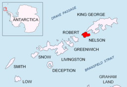
Edgell Bay
Edgell Bay er ei bukt på nordaustsida av Nelson Island i Sør-Shetlandsøyane. Denne bukta vart gravt skissert på kartet til Powell av Sør-Shetlandsøyane i 1822. Ho vart kartlagd på ny i 1934-35 av eit lag frå Discovery Investigations på «Discovery II», som namngav ho etter viseadmiral sir John Augustine Edgell i Royal Navy.[1][2]
| Edgell Bay | |||
| bukt | |||
| Land | |||
|---|---|---|---|
| Stad | Nelson Island | ||
| - koordinatar | 62°16′S 58°59′W / 62.267°S 58.983°W | ||
| Lengd | 3 km | ||
| Administrert under | Antarktistraktaten | ||
 Edgell Bay 62°16′00″S 58°59′00″W / 62.2667°S 58.9833°W | |||
Kjelder endre
- ↑ «Edgell Bay». Geographic Names Information System. United States Geological Survey, United States Department of the Interior. Henta 15. november 2012.
- ↑ «Edgell Bay». Gna-GeographicNamesOfTheAntarctic1stEdition1981_djvu. s. 602. Henta 15. november 2012.
Denne artikkelen inneheld stoff som er offentleg eige frå United States Geological Survey-artikkelen «Edgell Bay» (innhald frå Geographic Names Information System).

