Fil:2022 Russian invasion of Ukraine.svg

Opphavleg fil (SVG-fil, standardoppløysing: 2 199 × 1 478 pikslar, filstorleik: 3,72 MB)
Følgjande er henta frå filomtalen åt denne fila på Wikimedia Commons:
Rules for editing the map
|
| All edit warring, adding of unsourced information or performing a color change without consensus may result in the user being blocked. All contributions should first be discussed on the talk page. |
Skildring

|
This file may be updated to reflect new information. If you wish to use a specific version of the file without new updates being mirrored, please upload the required version as a separate file. |
| Skildring |
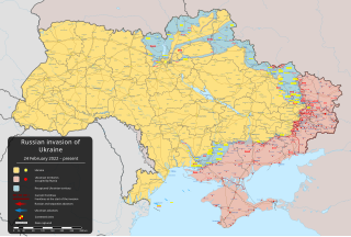
English: den russiske invasjonen av Ukraina i 2022 – russisk militærinvasjon av Ukraina som startet 24. februar 2022 [] |
||
| Dato | 24. februar 2022 (first version) | ||
| Kjelde |
Own work based on: Russo-Ukrainian conflict (2014-2022).svg fra Rr016 & Ukraine adm location map improved.svg fra Yakiv Gluck
|
||
| Opphavsperson | Viewsridge | ||
| Andre versjonar |
[]
|
||
| SVG utvikling | Kjeldekoden til denne gyldig. Vektorgrafikken vart laga med Inkscape. This map is translated using SVG switch elements: all translations are stored in the same file.
|


.gif)

.gif)


_en.png)
_vi.png)
_ru.png)
.svg)
This file is translated using SVG For most Wikipedia projects, you can embed the file normally (without a To translate the text into your language, you can use the SVG Translate tool. Alternatively, you can download the file to your computer, add your translations using whatever software you're familiar with, and re-upload it with the same name. You will find help in Graphics Lab if you're not sure how to do this. |
Lisensiering:
- Du står fritt til å:
- til å dela – til å kopiera, distibuera og overføra arbeidet
- til å blanda – til å endra verket
- På desse vilkåra:
- namngjeving – Du lyt godskriva verket på den måten som opphavpersonen eller lisensgjevaren har oppgjeve (men ikkje på ein slik måte at det kan verka som om dei går god for deg eller måten du nyttar verket på).
- del på same vilkåra – Om du remiksar, omarbeider, eller på annan måte byggjer på dette verket, kan du berre distribuera resultatet under den same eller ein samsvarande lisens som denne.
Filhistorikk
Klikk på dato/klokkeslett for å sjå fila slik ho var på det tidspunktet.
| Dato/klokkeslett | Miniatyrbilete | Oppløysing | Brukar | Kommentar | |
|---|---|---|---|---|---|
| gjeldande | 13. mai 2024 kl. 07:36 | | 2 199 × 1 478 (3,72 MB) | Alexiscoutinho | Updated Vovchansk per detailed map |
| 13. mai 2024 kl. 04:49 |  | 2 199 × 1 478 (3,72 MB) | Physeters | Updates per the ISW; for future reference, sources (like SuriyakMaps) must first have their reliability vetted on the talk page before they can be used to update the map; at the moment, the only two verified sources are the ISW and the Detailed Map on Wikipedia | |
| 12. mai 2024 kl. 12:34 |  | 2 199 × 1 478 (3,31 MB) | BlackShadowG | File uploaded using svgtranslate tool (https://svgtranslate.toolforge.org/). Added translation for zh-tw. | |
| 12. mai 2024 kl. 10:46 |  | 2 199 × 1 478 (3,31 MB) | Miki1234568 | File uploaded using svgtranslate tool (https://svgtranslate.toolforge.org/). Added translation for pl. | |
| 12. mai 2024 kl. 09:54 |  | 2 199 × 1 478 (3,31 MB) | BlackShadowG | File uploaded using svgtranslate tool (https://svgtranslate.toolforge.org/). Added translation for zh-cn. | |
| 12. mai 2024 kl. 01:02 |  | 2 199 × 1 478 (3,71 MB) | Mattia332 | As per Renowned Unbiased Open Source "SuriyakMaps", Russian progress in Kharkov | |
| 10. mai 2024 kl. 21:38 |  | 2 199 × 1 478 (3,71 MB) | Physeters | add date marker | |
| 10. mai 2024 kl. 21:31 |  | 2 199 × 1 478 (3,71 MB) | Physeters | Update per the ISW; Russia re-enters northern Kharkiv Oblast | |
| 9. mai 2024 kl. 06:45 |  | 2 199 × 1 478 (3,7 MB) | Physeters | Updates per the ISW; add Ocheretyne | |
| 8. mai 2024 kl. 21:22 |  | 2 199 × 1 478 (3,7 MB) | Alexiscoutinho | Updated Kyslivka per detailed map |
Filbruk
Den følgjande sida bruker denne fila:
Global filbruk
Desse andre wikiane nyttar fila:
- Bruk på af.wikipedia.org
- Bruk på als.wikipedia.org
- Bruk på am.wikipedia.org
- Bruk på ang.wikipedia.org
- Bruk på an.wikipedia.org
- Bruk på ar.wikipedia.org
- Bruk på ary.wikipedia.org
- Bruk på arz.wikipedia.org
- Bruk på ast.wikipedia.org
- Bruk på azb.wikipedia.org
- Bruk på az.wikipedia.org
- Bruk på bat-smg.wikipedia.org
- Bruk på bcl.wikipedia.org
- Bruk på be-tarask.wikipedia.org
- Bruk på be.wikipedia.org
- Bruk på bg.wikipedia.org
- Bruk på bh.wikipedia.org
- Bruk på bn.wikipedia.org
- Bruk på br.wikipedia.org
- Bruk på bs.wikipedia.org
- Bruk på bxr.wikipedia.org
- Bruk på ca.wikipedia.org
Sjå meir global bruk av denne fila.