Fil:Census Regions and Divisions.PNG
Storleik på førehandsvising: 788 × 600 pikslar. Andre oppløysingar: 315 × 240 pikslar | 631 × 480 pikslar | 909 × 692 pikslar.
Opphavleg fil (909 × 692 pikslar, filstorleik: 92 KB, MIME-type: image/png)
Følgjande er henta frå filomtalen åt denne fila på Wikimedia Commons:
Skildring

|
This map has been uploaded by Electionworld from en.wikipedia.org to enable the |
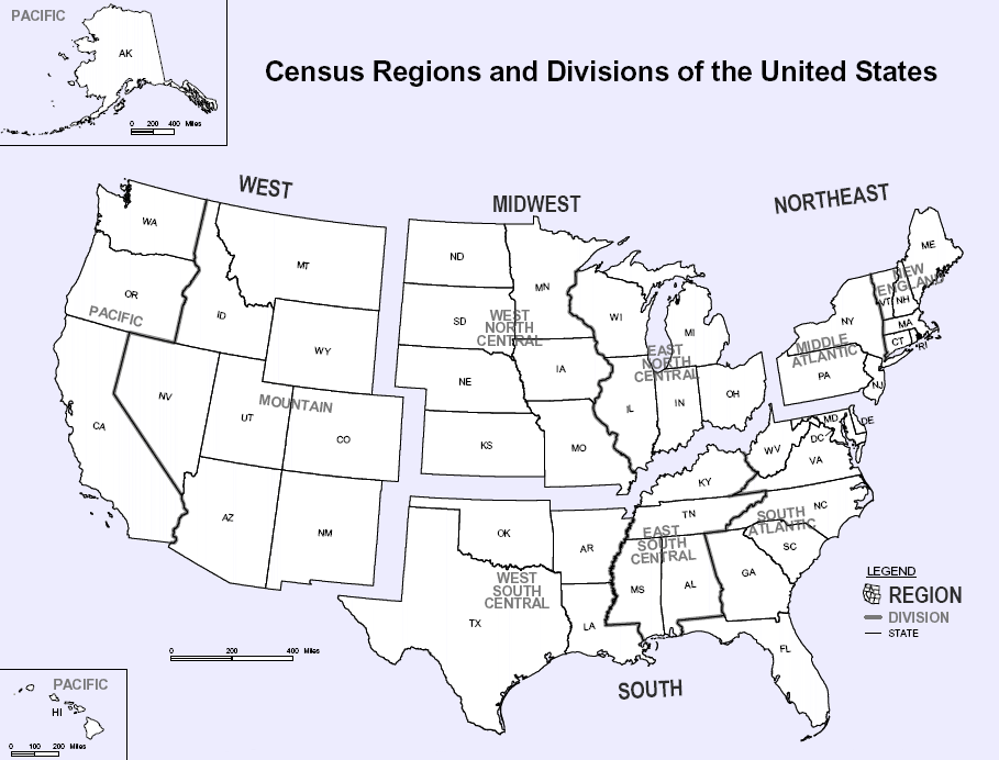
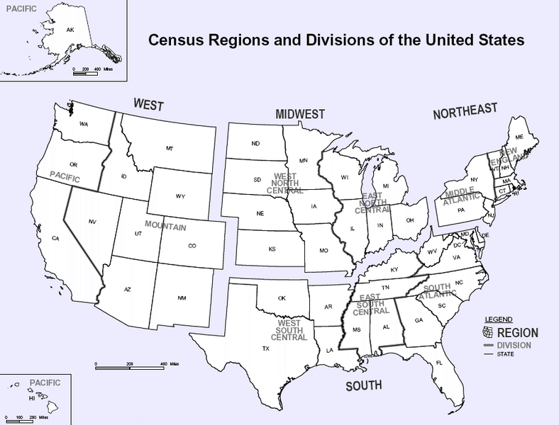
Map of U.S. Census Regions and Divisions. This map shows the four official US Census Regions, and the nine official Divisions within those Regions. See also: Image:US Census regional map.gif.
Lisensiering:
This work is in the public domain in the United States because it is a work prepared by an officer or employee of the United States Government as part of that person’s official duties under the terms of Title 17, Chapter 1, Section 105 of the US Code.
Note: This only applies to original works of the Federal Government and not to the work of any individual U.S. state, territory, commonwealth, county, municipality, or any other subdivision. This template also does not apply to postage stamp designs published by the United States Postal Service since 1978. (See § 313.6(C)(1) of Compendium of U.S. Copyright Office Practices). It also does not apply to certain US coins; see The US Mint Terms of Use.
|
 | |
| Denne fila er fastsett å vera fri for kjende avgrensingar under opphavsrettlovgjeving, medrekna alle relaterte og nærliggjande rettar. | ||

|
Ein vektorversjon av dette biletet (SVG) er tilgjengeleg.
Han bør verta nytta i staden for dette rasterbiletet der han er betre. File:Census Regions and Divisions.PNG → File:Census Regions and Division of the United States.svg
For meir informasjon om vektorgrafikk, les om overgangen til SVG på commons. Det finst òg informasjon om støtta MediaWiki har for SVG-bilete. |
 |
Filhistorikk
Klikk på dato/klokkeslett for å sjå fila slik ho var på det tidspunktet.
| Dato/klokkeslett | Miniatyrbilete | Oppløysing | Brukar | Kommentar | |
|---|---|---|---|---|---|
| gjeldande | 9. november 2023 kl. 13:56 | | 909 × 692 (92 KB) | Harold | Reverted to version as of 19:46, 13 June 2010 (UTC), COM:OW |
| 4. september 2020 kl. 00:08 |  | 2 200 × 1 700 (103 KB) | ACupOfCoffee | Census regions were changed in 2013. | |
| 13. juni 2010 kl. 21:46 |  | 909 × 692 (92 KB) | Ras67 | cropped, wm removed | |
| 30. november 2006 kl. 00:11 |  | 916 × 699 (107 KB) | Electionworld | {{ew|en|NThurston}} Map of U.S. Census Regions and Divisions. == Licensing == {{PD-USGov}} Category:Maps of the United States |
Filbruk
Den følgjande sida bruker denne fila:
Global filbruk
Desse andre wikiane nyttar fila:
- Bruk på bn.wikipedia.org
- Bruk på ca.wikipedia.org
- Bruk på de.wikipedia.org
- Bruk på en.wikipedia.org
- Bruk på eo.wikipedia.org
- Bruk på gl.wikipedia.org
- Bruk på it.wikipedia.org
- Bruk på ja.wikipedia.org
- Bruk på ko.wikipedia.org
- Bruk på ro.wikipedia.org
- Bruk på simple.wikipedia.org
- Bruk på sk.wikipedia.org
- Bruk på tr.wikipedia.org
- Bruk på vec.wikipedia.org
- Bruk på vi.wikipedia.org