Fil:Jian'an Commanderies.png
Storleik på førehandsvising: 800 × 576 pikslar. Andre oppløysingar: 320 × 230 pikslar | 640 × 461 pikslar | 1 024 × 737 pikslar | 1 280 × 922 pikslar | 2 500 × 1 800 pikslar.
Opphavleg fil (2 500 × 1 800 pikslar, filstorleik: 5,28 MB, MIME-type: image/png)
Følgjande er henta frå filomtalen åt denne fila på Wikimedia Commons:
Skildring

|
Ein vektorversjon av dette biletet (SVG) er tilgjengeleg.
Han bør verta nytta i staden for dette rasterbiletet der han er betre. File:Jian'an Commanderies.png → File:Jian'an Commanderies.svg
For meir informasjon om vektorgrafikk, les om overgangen til SVG på commons. Det finst òg informasjon om støtta MediaWiki har for SVG-bilete. |
 |
| Skildring |
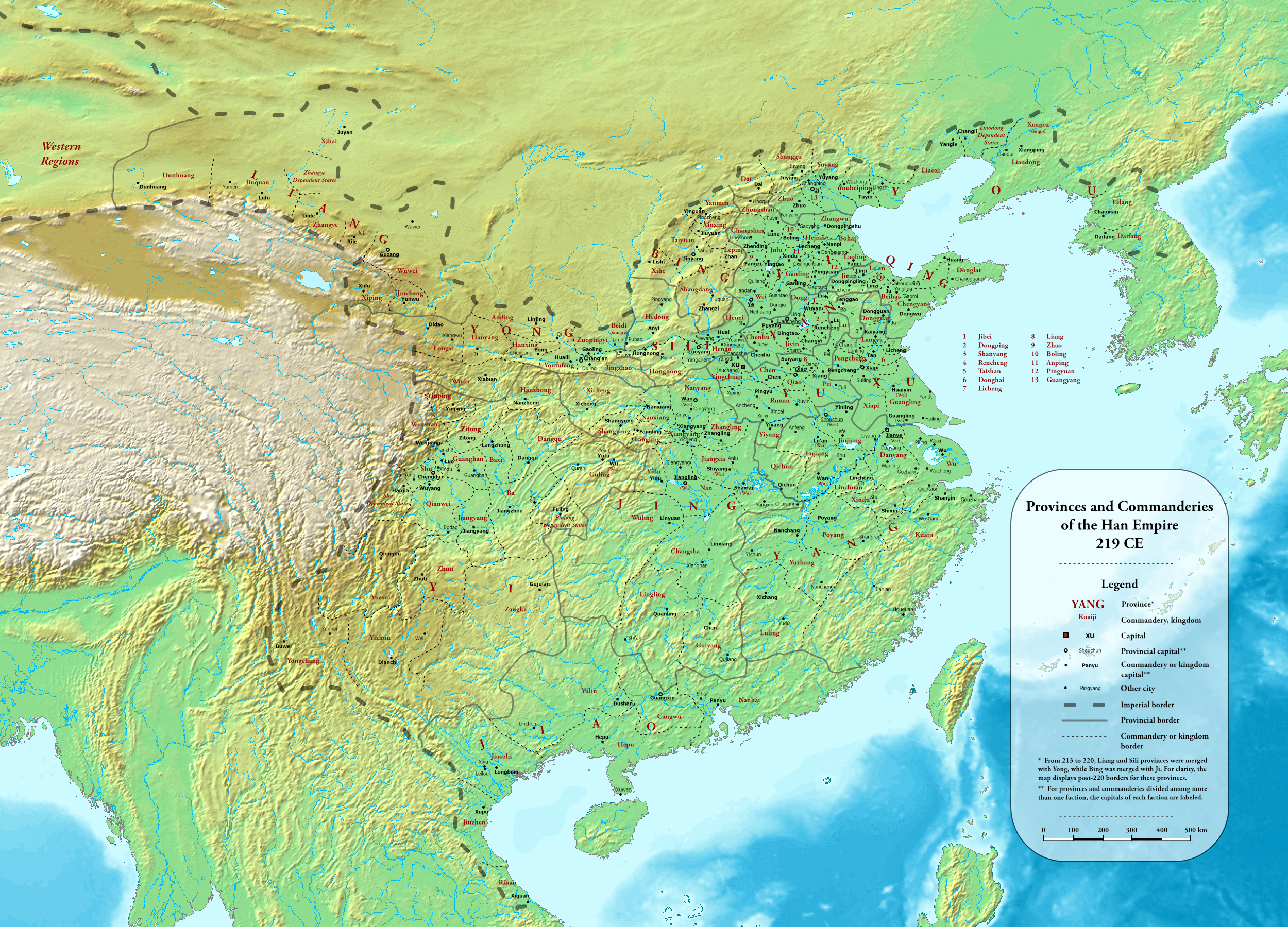
English: Provinces and commanderies of the Han Dynasty in 219 CE, during the Jian'an era
中文(简体):东汉建安时期州郡地图(建安二十四年,公元219年) |
| Dato | |
| Kjelde |
Own work using:
|
| Opphavsperson | Esiymbro |
Lisensiering:
Eg, opphavsrettshaldaren til verket, publiserer det hermed under denne lisensen:
Denne fila er lisensiert under lisensen Creative Commons Namngjeving-DelPåSameVilkåra 4.0 internasjonal.
- Du står fritt til å:
- til å dela – til å kopiera, distibuera og overføra arbeidet
- til å blanda – til å endra verket
- På desse vilkåra:
- namngjeving – Du lyt godskriva verket på den måten som opphavpersonen eller lisensgjevaren har oppgjeve (men ikkje på ein slik måte at det kan verka som om dei går god for deg eller måten du nyttar verket på).
- del på same vilkåra – Om du remiksar, omarbeider, eller på annan måte byggjer på dette verket, kan du berre distribuera resultatet under den same eller ein samsvarande lisens som denne.
Filhistorikk
Klikk på dato/klokkeslett for å sjå fila slik ho var på det tidspunktet.
| Dato/klokkeslett | Miniatyrbilete | Oppløysing | Brukar | Kommentar | |
|---|---|---|---|---|---|
| gjeldande | 20. mai 2022 kl. 03:54 | | 2 500 × 1 800 (5,28 MB) | Esiymbro | Corrections and more details |
| 18. mai 2022 kl. 18:22 |  | 2 500 × 1 800 (5,28 MB) | Esiymbro | DS borders; other corrections | |
| 21. mars 2022 kl. 17:31 |  | 2 500 × 1 800 (5,28 MB) | Esiymbro | Correcting a name; rewording legend notes | |
| 14. juli 2020 kl. 08:43 |  | 2 500 × 1 800 (5,28 MB) | Esiymbro | Corrections and more details | |
| 12. juli 2020 kl. 05:22 |  | 2 500 × 1 800 (5,28 MB) | Esiymbro | Corrections and more details | |
| 10. juli 2020 kl. 04:13 |  | 2 500 × 1 800 (5,25 MB) | Esiymbro | {{Information |description ={{en|1=Provinces and commanderies of the Han Dynasty in 219 CE, during the Jian'an era}} {{zh|1=东汉建安时期州郡地图(建安二十四年,公元219年)}} |date =2020-07-10 |source ={{own}} |author =User:Esiymbro }} Category:Maps of the Han Dynasty Category:Maps of the Three Kingdoms |
Filbruk
Den følgjande sida bruker denne fila:
Global filbruk
Desse andre wikiane nyttar fila:
- Bruk på en.wikipedia.org
- Bruk på es.wikipedia.org
- Bruk på ko.wikipedia.org
- Bruk på ms.wikipedia.org
- Bruk på mt.wikipedia.org
- Bruk på pl.wikipedia.org
- Bruk på sl.wikipedia.org
- Bruk på sq.wikipedia.org
- Bruk på th.wikipedia.org
- Bruk på uk.wikipedia.org
- Bruk på vi.wikipedia.org