Fil:Missouri River basin map.png

Storleik på førehandsvising: 800 × 575 pikslar. Andre oppløysingar: 320 × 230 pikslar | 640 × 460 pikslar | 1 024 × 736 pikslar | 1 280 × 920 pikslar | 1 496 × 1 075 pikslar.
Opphavleg fil (1 496 × 1 075 pikslar, filstorleik: 2,63 MB, MIME-type: image/png)
Følgjande er henta frå filomtalen åt denne fila på Wikimedia Commons:
Skildring
| Skildring |
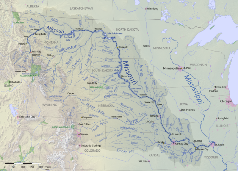
English: Map of the Missouri River drainage basin in the US and Canada. made using USGS and Natural Earth data. Replacement for File:Missouririvermap.jpg. |
| Dato | |
| Kjelde | Eige arbeid |
| Opphavsperson | Shannon1 |
.png)
Lisensiering:
Eg, opphavsrettshaldaren til verket, publiserer det hermed under desse lisensane:

|
Det er tillate å kopiera, distribuera og/eller modifisera dette dokumentet under retningslinene som er skildra i GNU fri dokumentasjonslisens, versjon 1.2 eller seinare utgåve utgjeven av Free Software Foundation; med alle seksjonane, utan nokon framsidetekstar og baksidetekstar. Ein kopi av lisensen er inkludert i avsnittet GNU Free Documentation License. |
This file is licensed under the Creative Commons Attribution-Share Alike Attribution-Share Alike 4.0 International, 3.0 Unported, 2.5 Generic, 2.0 Generic and 1.0 Generic license.
- Du står fritt til å:
- til å dela – til å kopiera, distibuera og overføra arbeidet
- til å blanda – til å endra verket
- På desse vilkåra:
- namngjeving – Du lyt godskriva verket på den måten som opphavpersonen eller lisensgjevaren har oppgjeve (men ikkje på ein slik måte at det kan verka som om dei går god for deg eller måten du nyttar verket på).
- del på same vilkåra – Om du remiksar, omarbeider, eller på annan måte byggjer på dette verket, kan du berre distribuera resultatet under den same eller ein samsvarande lisens som denne.
Du kan velje den lisensen du sjølv tykkjer er best.
Filhistorikk
Klikk på dato/klokkeslett for å sjå fila slik ho var på det tidspunktet.
| Dato/klokkeslett | Miniatyrbilete | Oppløysing | Brukar | Kommentar | |
|---|---|---|---|---|---|
| gjeldande | 9. april 2018 kl. 02:15 | | 1 496 × 1 075 (2,63 MB) | Shannon1 | missing label |
| 30. mars 2018 kl. 23:56 |  | 1 500 × 1 080 (2,8 MB) | Shannon1 | slight fixes | |
| 30. mars 2018 kl. 21:30 |  | 1 500 × 1 078 (2,78 MB) | Shannon1 | {{Information |description ={{en|1=Map of the Missouri River drainage basin in the US and Canada. made using USGS and Natural Earth data. Replacement for File:Missouririvermap.jpg.}} |source =Own work |author =Shannon1 |date =2018-03-21 }} Category:Missouri River |
Filbruk
Den følgjande sida bruker denne fila:
Global filbruk
Desse andre wikiane nyttar fila:
- Bruk på af.wikipedia.org
- Bruk på azb.wikipedia.org
- Bruk på az.wiktionary.org
- Bruk på ba.wikipedia.org
- Bruk på be.wikipedia.org
- Bruk på bh.wikipedia.org
- Bruk på bn.wikipedia.org
- Bruk på ca.wikipedia.org
- Bruk på cv.wikipedia.org
- Bruk på da.wikipedia.org
- Bruk på en.wikipedia.org
- Missouri River
- Grand River (South Dakota)
- User:Shannon1/Sandbox 5
- User:Shannon1/Maps
- Yellowstone expedition
- List of longest rivers of the United States (by main stem)
- List of tributaries of the Missouri River
- Wikipedia:Graphics Lab/Map workshop/Archive/Jul 2011
- List of dams in the Missouri River watershed
- User:Shannon1/Maps/to-do
- Joseph LaBarge
- Spread Eagle (steamboat)
- Emilie (steamboat)
- Bruk på es.wikipedia.org
- Iowa
- Dakota del Norte
- Dakota del Sur
- Denver
- Río Misuri
- Bismarck (Dakota del Norte)
- Misuri
- Río Yellowstone
- Lincoln (Nebraska)
- Omaha (Nebraska)
- Columbia (Misuri)
- Kansas City (Misuri)
- Topeka
- Río Marías
- Kansas City (Kansas)
- Río Cheyenne
- Río Gallatin
- Great Falls (Montana)
- Río Platte
- Río Milk
- Río James (Dakotas)
- Río Smoky Hill
- Río Saline (Kansas)
- Río Niobrara
Sjå meir global bruk av denne fila.