Fil:Topographical Map of Traditional Galloway.png

Storleik på førehandsvising: 796 × 600 pikslar. Andre oppløysingar: 319 × 240 pikslar | 637 × 480 pikslar | 1 020 × 768 pikslar | 1 280 × 964 pikslar | 1 479 × 1 114 pikslar.
Opphavleg fil (1 479 × 1 114 pikslar, filstorleik: 909 KB, MIME-type: image/png)
Følgjande er henta frå filomtalen åt denne fila på Wikimedia Commons:
Skildring
| Skildring |
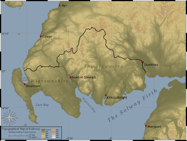
Created by myself, Topographical Map of the area of SW Scotland traditionally defined as Galloway (the counties of Wigtownshire and The Stewartry).
|
| Dato | 28. februar 2006 (original upload date) |
| Kjelde | Inga maskinlesbar kjelde er oppgjeven. Frå påstandar om opphavsrett vert det rekna med at det er eige arbeid. |
| Opphavsperson | Ingen maskinlesbar opphavsperson er oppgjeven. Frå påstandar om opphavsrett vert det rekna med at SFC9394 er opphavsperson. |
Lisensiering:
Eg, opphavsrettshaldaren til verket, publiserer det hermed under desse lisensane:

|
Det er tillate å kopiera, distribuera og/eller modifisera dette dokumentet under retningslinene som er skildra i GNU fri dokumentasjonslisens, versjon 1.2 eller seinare utgåve utgjeven av Free Software Foundation; med alle seksjonane, utan nokon framsidetekstar og baksidetekstar. Ein kopi av lisensen er inkludert i avsnittet GNU Free Documentation License. |
| Denne fila er lisensiert under lisensen Creative Commons Namngjeving-DelPåSameVilkåra 3.0 Unported | ||
| ||
| Dette lisensieringsmerket vart lagt til denne fila som ein del av GFDL-lisensieringsoppdateringa. |
Denne filene er lisensiert under Creative Commons Navngivelse 2.5 Generisk-lisensen
- Du står fritt til å:
- til å dela – til å kopiera, distibuera og overføra arbeidet
- til å blanda – til å endra verket
- På desse vilkåra:
- namngjeving – Du lyt godskriva verket på den måten som opphavpersonen eller lisensgjevaren har oppgjeve (men ikkje på ein slik måte at det kan verka som om dei går god for deg eller måten du nyttar verket på).
Du kan velje den lisensen du sjølv tykkjer er best.
Filhistorikk
Klikk på dato/klokkeslett for å sjå fila slik ho var på det tidspunktet.
| Dato/klokkeslett | Miniatyrbilete | Oppløysing | Brukar | Kommentar | |
|---|---|---|---|---|---|
| gjeldande | 1. mars 2006 kl. 23:31 | | 1 479 × 1 114 (909 KB) | SFC9394 | |
| 28. februar 2006 kl. 16:23 |  | 1 479 × 1 114 (906 KB) | SFC9394 | ||
| 28. februar 2006 kl. 16:08 |  | 1 479 × 1 114 (892 KB) | SFC9394 | Created by myself, Topographical Map of the area of SW Scotland traditionally defined as Galloway (the counties of Wigtownshire and The Stewartry). Topographical data derived from NASA SRTM, public domain. County boundaries derived from 1821 map of sout |
Filbruk
Den følgjande sida bruker denne fila:
Global filbruk
Desse andre wikiane nyttar fila:
- Bruk på da.wikipedia.org
- Bruk på en.wikipedia.org
- Bruk på en.wiktionary.org
- Bruk på es.wikipedia.org
- Bruk på fr.wikipedia.org
- Bruk på it.wikipedia.org
- Bruk på no.wikipedia.org
- Bruk på pt.wikipedia.org