Fil:Derwentcroped.jpg
Høgare oppløysing er ikkje tilgjengeleg.
Derwentcroped.jpg (224 × 453 pikslar, filstorleik: 19 KB, MIME-type: image/jpeg)
Følgjande er henta frå filomtalen åt denne fila på Wikimedia Commons:
Skildring
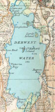
Derwent Water on a 1925 Ordnance Survey map
- This work is in the public domain because it is an Ordnance Survey map over 50 years old. Ordnance Survey maps are covered by crown copyright which in this case expires 50 years after publication. Ordnance Survey does however ask that they be credited and that the date of publication be given. Any ancillary rights gained through the creation of the electronic version are granted as freely usable under any circumstances.
Lisensiering:
This work is an Ordnance Survey map over 50 years old, which is covered by Crown Copyright which in this case expires 50 years after publication. Ordnance Survey does however ask that they be credited and that the date of publication be given.
Any ancillary rights gained through the creation of the electronic version are granted as freely usable under any circumstances.
|
This work created by the United Kingdom Government is in the public domain.
This is because it is one of the following:
HMSO has declared that the expiry of Crown Copyrights applies worldwide (ref: HMSO Email Reply)
|
 |
Filhistorikk
Klikk på dato/klokkeslett for å sjå fila slik ho var på det tidspunktet.
| Dato/klokkeslett | Miniatyrbilete | Oppløysing | Brukar | Kommentar | |
|---|---|---|---|---|---|
| gjeldande | 18. oktober 2006 kl. 00:22 | | 224 × 453 (19 KB) | Voyager | == Summary == Derwent Water on a 1925 Ordnance Survey map :This work is in the public domain because it is an Ordnance Survey map over 50 years old. Ordnance Survey maps are covered by crown copyright which in this case expires 50 years after publication |
Filbruk
Den følgjande sida bruker denne fila:
Global filbruk
Desse andre wikiane nyttar fila:
- Bruk på cy.wikipedia.org
- Bruk på de.wikipedia.org
- Bruk på it.wikipedia.org
- Bruk på nl.wikipedia.org
- Bruk på pnb.wikipedia.org
- Bruk på ru.wikipedia.org
- Bruk på simple.wikipedia.org