Fil:Flores map.png
Høgare oppløysing er ikkje tilgjengeleg.
Flores_map.png (300 × 122 pikslar, filstorleik: 21 KB, MIME-type: image/png)
Følgjande er henta frå filomtalen åt denne fila på Wikimedia Commons:

|
Dette locator map biletet bør verta oppretta på nytt som vektorgrafikk i SVG-format. Dette har fleire føremoner; sjå Commons:Media for cleanup for meir informasjon. Om ein SVG-versjon av dette biletet alt er tilgjengeleg, gjer vel og last han opp. Ettar å ha lasta opp ei SVG-fil, erstatt denne malen med {{vector version available|nytt biletnamn.svg}}.
|
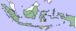
This image was copied from wikipedia:en. The original description was:
Map showing Flores Island within Indonesia
| Eg, opphavsrettshaldaren til dette verket, frigjev dette verket til ålmenta. Dette gjeld over heile verda. I somme landa er dette kan henda ikkje rettsleg mogeleg. I det fall: Eg gjev kven som helst rettane til å nytta dette verket for kva som helst føremål og utan vilkår, minder vilkår er kravde etter lova. |
| date/time | username | edit summary |
|---|---|---|
| 14:17, 14 March 2005 | *drew | (Map showing Flores Island within Indonesia) |
Filhistorikk
Klikk på dato/klokkeslett for å sjå fila slik ho var på det tidspunktet.
| Dato/klokkeslett | Miniatyrbilete | Oppløysing | Brukar | Kommentar | |
|---|---|---|---|---|---|
| gjeldande | 2. februar 2007 kl. 12:19 | 300 × 122 (21 KB) | J. Patrick Fischer | The original image was copied from wikipedia:en. The image was corrected by user:J. Patrick Fischer (two islands east of Flores were wrong marked as part of Flores before). The original description was: Map showing Flores Island within Indonesia {{ | |
| 10. oktober 2006 kl. 14:26 | 300 × 122 (16 KB) | UtherSRG | Change color. | ||
| 5. oktober 2005 kl. 14:27 | 300 × 122 (15 KB) | ChongDae | This image was copied from wikipedia:en. The original description was: Map showing Flores Island within Indonesia {{PD}} {| border="1" ! date/time || username || edit summary |---- | 14:17, 14 March 2005 || *drew || <nowiki>(Map showing Flores Island wi |
Filbruk
Den følgjande sida bruker denne fila:
Global filbruk
Desse andre wikiane nyttar fila:
- Bruk på az.wikipedia.org
- Bruk på cy.wikipedia.org
- Bruk på el.wikipedia.org
- Bruk på en.wikipedia.org
- Bruk på en.wikivoyage.org
- Bruk på en.wiktionary.org
- Bruk på eo.wikipedia.org
- Bruk på fi.wikipedia.org
- Bruk på fr.wikipedia.org
- Bruk på gl.wikipedia.org
- Bruk på he.wikipedia.org
- Bruk på id.wikipedia.org
- Bruk på ilo.wikipedia.org
- Bruk på it.wikipedia.org
- Bruk på ko.wikipedia.org
- Bruk på min.wikipedia.org
- Bruk på ml.wikipedia.org
- Bruk på nl.wikipedia.org
- Bruk på pt.wikipedia.org
- Bruk på tr.wikipedia.org
- Bruk på zh.wikipedia.org