Fil:French Mandate for Syria and the Lebanon map en.svg

Storleik på denne PNG-førehandsvisinga av denne SVG-fila: 725 × 599 pikslar. Andre oppløysingar: 290 × 240 pikslar | 581 × 480 pikslar | 929 × 768 pikslar | 1 239 × 1 024 pikslar | 2 478 × 2 048 pikslar | 922 × 762 pikslar.
Opphavleg fil (SVG-fil, standardoppløysing: 922 × 762 pikslar, filstorleik: 245 KB)
Følgjande er henta frå filomtalen åt denne fila på Wikimedia Commons:
Skildring
| Skildring |
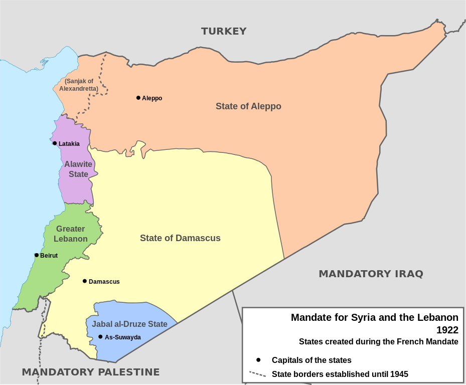
English: Map of French Mandate for Syria and the Lebanon and the states created in 1922, in English. Sources:
|
| Dato | |
| Kjelde | Eige arbeid, based on File:Syria, administrative divisions - de - colored.svg |
| Opphavsperson | Don-kun, TUBS, NordNordWest |
| Andre versjonar |
[]
|


Lisensiering:
Eg, opphavsrettshaldaren til verket, publiserer det hermed under desse lisensane:

|
Det er tillate å kopiera, distribuera og/eller modifisera dette dokumentet under retningslinene som er skildra i GNU fri dokumentasjonslisens, versjon 1.2 eller seinare utgåve utgjeven av Free Software Foundation; med alle seksjonane, utan nokon framsidetekstar og baksidetekstar. Ein kopi av lisensen er inkludert i avsnittet GNU Free Documentation License. |
Fila er lisensiert under Creative Commons Namngjeving 3.0 Unported.
- Du står fritt til å:
- til å dela – til å kopiera, distibuera og overføra arbeidet
- til å blanda – til å endra verket
- På desse vilkåra:
- namngjeving – Du lyt godskriva verket på den måten som opphavpersonen eller lisensgjevaren har oppgjeve (men ikkje på ein slik måte at det kan verka som om dei går god for deg eller måten du nyttar verket på).
Du kan velje den lisensen du sjølv tykkjer er best.
Filhistorikk
Klikk på dato/klokkeslett for å sjå fila slik ho var på det tidspunktet.
| Dato/klokkeslett | Miniatyrbilete | Oppløysing | Brukar | Kommentar | |
|---|---|---|---|---|---|
| gjeldande | 4. februar 2013 kl. 18:05 | | 922 × 762 (245 KB) | AnonMoos | Change "Libanon" to "Lebanon" |
| 4. februar 2013 kl. 17:33 |  | 922 × 762 (250 KB) | Don-kun | fix border to palestine, source: http://en.wikisource.org/wiki/Franco-British_Convention_on_Certain_Points_Connected_with_the_Mandates_for_Syria_and_the_Lebanon,_Palestine_and_Mesopotamia | |
| 30. januar 2013 kl. 20:43 |  | 922 × 762 (248 KB) | Don-kun | minus ahistorical lakes (and so all waterbodies) | |
| 26. januar 2013 kl. 23:44 |  | 922 × 762 (282 KB) | Don-kun | {{Information |Description ={{en|1=Map of French Mandate for Syria and the Lebanon and the states created in 1922, in English.}} |Source ={{own}}, based on File:Syria, administrative divisions - de - colored.svg |Author =[[User:... |
Filbruk
Den følgjande sida bruker denne fila:
Global filbruk
Desse andre wikiane nyttar fila:
- Bruk på af.wikipedia.org
- Bruk på ar.wikipedia.org
- Bruk på ast.wikipedia.org
- Bruk på azb.wikipedia.org
- Bruk på az.wikipedia.org
- Bruk på be.wikipedia.org
- Bruk på bg.wikipedia.org
- Bruk på bn.wikipedia.org
- Bruk på ca.wikipedia.org
- Bruk på cs.wikipedia.org
- Bruk på de.wikipedia.org
- Bruk på el.wikipedia.org
- Bruk på en.wikipedia.org
Sjå meir global bruk av denne fila.