Fil:Grimsaywheelhouse.jpg
Høgare oppløysing er ikkje tilgjengeleg.
Grimsaywheelhouse.jpg (640 × 480 pikslar, filstorleik: 118 KB, MIME-type: image/jpeg)
Følgjande er henta frå filomtalen åt denne fila på Wikimedia Commons:
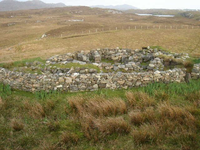
Skildring
| Skildring |
Grimsay Wheelhouse This is possibly the best preserved example of a wheelhouse on North Uist and is not shown on the OS maps. Difficult to find, it is located between Loch Hornary and the north coast of Grimsay. It dates from the Iron Age. Grimsay, Outer Hebrides, Scotland. |
| Dato | |
| Kjelde |
This image was taken from the Geograph project collection. See this photograph's page on the Geograph website for the photographer's contact details. The copyright on this image is owned by Bob Jones and is licensed for reuse under the Creative Commons Attribution-ShareAlike 2.0 license. From geograph.org.uk |
| Opphavsperson | Bob Jones |
| Løyve (Gjenbruk av denne fila) |
See below. |
| Namngjeving (påkravd av lisensen) | Bob Jones / Grimsay Wheelhouse / |
| Kameraposisjon | | Dette og andre bilete på denne posisjonen i: OpenStreetMap |
|---|
| Objektposisjon | | Dette og andre bilete på denne posisjonen i: OpenStreetMap |
|---|
_region:GB-GBN_heading:135.00&language=nn)
Lisensiering:

|
This image was taken from the Geograph project collection. See this photograph's page on the Geograph website for the photographer's contact details. The copyright on this image is owned by Bob Jones and is licensed for reuse under the Creative Commons Attribution-ShareAlike 2.0 license.
|
Denne filen er lisensiert under lisensen Creative Commons Navngivelse-DelPåSammeVilkår 2.0 Generisk
Namngjeving: Bob Jones
- Du står fritt til å:
- til å dela – til å kopiera, distibuera og overføra arbeidet
- til å blanda – til å endra verket
- På desse vilkåra:
- namngjeving – Du lyt godskriva verket på den måten som opphavpersonen eller lisensgjevaren har oppgjeve (men ikkje på ein slik måte at det kan verka som om dei går god for deg eller måten du nyttar verket på).
- del på same vilkåra – Om du remiksar, omarbeider, eller på annan måte byggjer på dette verket, kan du berre distribuera resultatet under den same eller ein samsvarande lisens som denne.
Filhistorikk
Klikk på dato/klokkeslett for å sjå fila slik ho var på det tidspunktet.
| Dato/klokkeslett | Miniatyrbilete | Oppløysing | Brukar | Kommentar | |
|---|---|---|---|---|---|
| gjeldande | 21. november 2007 kl. 19:50 | | 640 × 480 (118 KB) | MacRusgail | == Summary == {{Information |Description=Grimsay Wheelhouse This is possibly the best preserved example of a wheelhouse on North Uist and is not shown on the OS maps. Difficult to find, it is located between Loch Hornary and the north coast of Grimsay. It |
Filbruk
Den følgjande sida bruker denne fila:
Global filbruk
Desse andre wikiane nyttar fila:
- Bruk på el.wikipedia.org
- Bruk på en.wikipedia.org
- Bruk på en.wikivoyage.org
- Bruk på fa.wikipedia.org
- Bruk på fr.wikipedia.org
- Bruk på pl.wikipedia.org
- Bruk på pt.wikipedia.org
- Bruk på zh.wikipedia.org