Fil:Iraq.A2003060.0750.500m.jpg

Storleik på førehandsvising: 461 × 599 pikslar. Andre oppløysingar: 184 × 240 pikslar | 369 × 480 pikslar | 591 × 768 pikslar | 788 × 1 024 pikslar | 2 000 × 2 600 pikslar.
Opphavleg fil (2 000 × 2 600 pikslar, filstorleik: 1 012 KB, MIME-type: image/jpeg)
Følgjande er henta frå filomtalen åt denne fila på Wikimedia Commons:
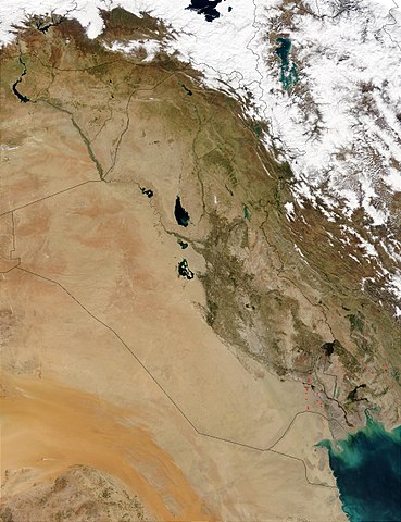
This Moderate Resolution Imaging Spectroradiometer (MODIS) image from March 1, 2003, shows numerous oil well flares (the burning off of combustible gases associated with oil) in southern Iraq (center). The way the active hot spots, marked in red, line up almost vertically suggests they are along a pipeline. Meanwhile, hot spots in southern Iran (right) are likely agricultural fires.
http://visibleearth.nasa.gov/view_rec.php?id=5166
| This file is in the public domain in the United States because it was solely created by NASA. NASA copyright policy states that "NASA material is not protected by copyright unless noted". (See Template:PD-USGov, NASA copyright policy page or JPL Image Use Policy.) | ||
 |
Warnings:
|
Filhistorikk
Klikk på dato/klokkeslett for å sjå fila slik ho var på det tidspunktet.
| Dato/klokkeslett | Miniatyrbilete | Oppløysing | Brukar | Kommentar | |
|---|---|---|---|---|---|
| gjeldande | 26. oktober 2005 kl. 17:05 | | 2 000 × 2 600 (1 012 KB) | Brian0918 | This Moderate Resolution Imaging Spectroradiometer (MODIS) image from March 1, 2003, shows numerous oil well flares (the burning off of combustible gases associated with oil) in southern Iraq (center). The way the active hot spots, marked in red, line up |
Filbruk
Dei følgjande 4 sidene bruker denne fila:
Global filbruk
Desse andre wikiane nyttar fila:
- Bruk på ar.wikipedia.org
- Bruk på ar.wikiquote.org
- Bruk på da.wikipedia.org
- Bruk på en.wikipedia.org
- Bruk på fi.wikipedia.org
- Bruk på gl.wikipedia.org
- Bruk på hr.wikipedia.org
- Bruk på hy.wikipedia.org
- Bruk på ka.wikipedia.org
- Bruk på km.wikipedia.org
- Bruk på ko.wikipedia.org
- Bruk på lt.wikipedia.org
- Bruk på mn.wikipedia.org
- Bruk på no.wikipedia.org
- Bruk på nrm.wikipedia.org
- Bruk på pl.wikipedia.org
- Bruk på pt.wikipedia.org
- Bruk på sh.wikipedia.org
- Bruk på sl.wikipedia.org
- Bruk på sr.wikipedia.org
- Bruk på sv.wikipedia.org
- Bruk på te.wikipedia.org
- Bruk på tr.wikipedia.org
- Bruk på uk.wikipedia.org
- Bruk på zh.wikipedia.org