Fil:Map of Cyrenaica.png

Storleik på førehandsvising: 800 × 543 pikslar. Andre oppløysingar: 320 × 217 pikslar | 640 × 434 pikslar | 918 × 623 pikslar.
Opphavleg fil (918 × 623 pikslar, filstorleik: 92 KB, MIME-type: image/png)
Følgjande er henta frå filomtalen åt denne fila på Wikimedia Commons:
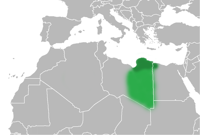
| Skildring | The Ottoman Turks conquered the country in the mid-16th century, and the three States or "Wilayat" of Tripolitania, Cyrenaica and Fezzan (which make up Libya) remained part of their empire with the exception of the virtual autonomy of the Karamanlis. The Karamanlis ruled from 1711 until 1835 mainly in Tripolitania, but had influence in Cyrenaica and Fezzan as well by the mid 18th century. |
| Dato | (UTC) |
| Kjelde | |
| Opphavsperson |
|
| Andre versjonar | File:Map of Cyrenaica.svg |
.png)
| This is a retouched picture, which means that it has been digitally altered from its original version. Modifications: changes of area Cyrenaica. The original can be viewed here: Ottoman Provinces Of Present day Libyapng.png:
|
| Eg, opphavsrettshaldaren til dette verket, frigjev dette verket til ålmenta. Dette gjeld over heile verda. I somme landa er dette kan henda ikkje rettsleg mogeleg. I det fall: Eg gjev kven som helst rettane til å nytta dette verket for kva som helst føremål og utan vilkår, minder vilkår er kravde etter lova. |
Opphavleg opplastingslogg
This image is a derivative work of the following images:
- File:United_States_of_North_Africa_Locator.png licensed with PD-self
- 2010-03-26T13:53:08Z Roxanna 1160x1056 (29795 Bytes) {{Information |Description={{en|1="United States of North Africa" (proposal by President [[en:Habib Bourguiba]] for Tunisia, Algeria and Libya 1973) and "Arab Islamic Republic" (proposal by [[en:Muammar al-Gaddafi]] for a uni
- File:Ottoman_Provinces_Of_Present_day_Libyapng.png licensed with PD-self
Uploaded with derivativeFX
Filhistorikk
Klikk på dato/klokkeslett for å sjå fila slik ho var på det tidspunktet.
| Dato/klokkeslett | Miniatyrbilete | Oppløysing | Brukar | Kommentar | |
|---|---|---|---|---|---|
| gjeldande | 1. juli 2010 kl. 22:51 | | 918 × 623 (92 KB) | Felitsata | change of border |
| 1. juli 2010 kl. 22:33 |  | 918 × 623 (93 KB) | Felitsata | {{Information |Description={{en|1="United States of North Africa" (proposal by President [http://en.wikipedia.org/wiki/Habib_Bourguiba Habib Bourguiba] for Tunisia, Algeria and Libya 1973) and "Arab Islamic Republic" (proposal by [http://en.wikipedia.org/ |
Filbruk
Den følgjande sida bruker denne fila:
Global filbruk
Desse andre wikiane nyttar fila:
- Bruk på bg.wikipedia.org
- Bruk på bn.wikipedia.org
- Bruk på en.wikipedia.org
- Bruk på es.wikipedia.org
- Bruk på fi.wikipedia.org
- Bruk på he.wikipedia.org
- Bruk på hr.wikipedia.org
- Bruk på hy.wikipedia.org
- Bruk på inh.wikipedia.org
- Bruk på it.wikipedia.org
- Bruk på ja.wikipedia.org
- Bruk på ko.wikipedia.org
- Bruk på la.wiktionary.org
- Bruk på pl.wiktionary.org
- Bruk på ro.wikipedia.org
- Bruk på ru.wikipedia.org
- Bruk på sh.wikipedia.org
- Bruk på sl.wikipedia.org
- Bruk på sr.wikipedia.org
- Bruk på th.wikipedia.org
- Bruk på tr.wikipedia.org
- Bruk på uk.wikipedia.org