Fil:SiegeOfQuebec1759ByDesBarres.jpg

Storleik på førehandsvising: 800 × 386 pikslar. Andre oppløysingar: 320 × 154 pikslar | 640 × 309 pikslar | 1 024 × 494 pikslar | 1 280 × 617 pikslar | 2 560 × 1 234 pikslar | 6 854 × 3 304 pikslar.
Opphavleg fil (6 854 × 3 304 pikslar, filstorleik: 8,58 MB, MIME-type: image/jpeg)
Følgjande er henta frå filomtalen åt denne fila på Wikimedia Commons:
Skildring
| Skildring |
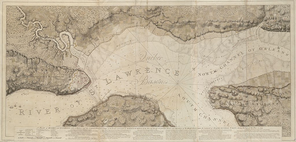
English: This is a map depicting the troop arrangements at the 1759 Siege of Quebec. The caption reads: A Plan of Quebec and Environs, with its Defenses and the occasional entrenched Camps of the French commanded by Marquis de Montcalme; shewing likewise the principal Works and Operations of the British Forces, under the command of Major General Wolfe, during the Siege of that Place in 1759.
Français : Cette carte montre la disposition des troupes durant le Siège de Québec de 1759. |
| Dato | published 1777 |
| Kjelde | Call Number: G1106.P5 1777 .D4 |
| Opphavsperson | Joseph F. W. Des Barres |
Lisensiering:
This media file is in the public domain in the United States. This applies to U.S. works where the copyright has expired, often because its first publication occurred prior to January 1, 1929, and if not then due to lack of notice or renewal. See this page for further explanation.
|
 | |
 |
This image might not be in the public domain outside of the United States; this especially applies in the countries and areas that do not apply the rule of the shorter term for US works, such as Canada, Mainland China (not Hong Kong or Macao), Germany, Mexico, and Switzerland. The creator and year of publication are essential information and must be provided. See Wikipedia:Public domain and Wikipedia:Copyrights for more details.
|
Filhistorikk
Klikk på dato/klokkeslett for å sjå fila slik ho var på det tidspunktet.
| Dato/klokkeslett | Miniatyrbilete | Oppløysing | Brukar | Kommentar | |
|---|---|---|---|---|---|
| gjeldande | 25. juli 2009 kl. 04:21 | | 6 854 × 3 304 (8,58 MB) | Magicpiano | {{Information |Description={{en|1=This is a map depicting the troop arrangements at the 1759 Siege of Quebec. The caption reads: A Plan of Quebec and Environs, with its Defenses and the occasional entrenched Camps of the Fren |
Filbruk
Den følgjande sida bruker denne fila:
Global filbruk
Desse andre wikiane nyttar fila:
- Bruk på ca.wikipedia.org
- Bruk på de.wikipedia.org
- Bruk på en.wikipedia.org
- Bruk på es.wikipedia.org
- Bruk på fr.wikipedia.org
- Bruk på it.wikipedia.org
- Bruk på ru.wikipedia.org
- Bruk på uk.wikipedia.org
- Bruk på www.wikidata.org