Fil:TNF-NASAmap-Labels.png
Høgare oppløysing er ikkje tilgjengeleg.
TNF-NASAmap-Labels.png (720 × 436 pikslar, filstorleik: 431 KB, MIME-type: image/png)
Følgjande er henta frå filomtalen åt denne fila på Wikimedia Commons:
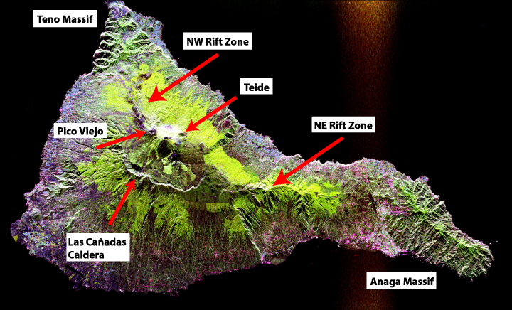
Skildring
Edited from original file to add in geological labels (the Teide/Pico Viejo massif, rift zones, Miocence shield volcano massifs and the Las Cañadas Caldera)
Space radar image of Teide, taken in 1994. NASA's description:
- This radar image shows the Teide volcano on the island of Tenerife in the Canary Islands. The Canary Islands, part of Spain, are located in the eastern Atlantic Ocean off the coast of Morocco. Teide has erupted only once in the 20th Century, in 1909, but is considered a potentially threatening volcano due to its proximity to the city of Santa Cruz de Tenerife, shown in this image as the purple and white area on the lower right edge of the island. The summit crater of Teide, clearly visible in the left center of the image, contains lava flows of various ages and roughnesses that appear in shades of green and brown. Different vegetation zones, both natural and agricultural, are detected by the radar as areas of purple, green and yellow on the volcano's flanks. Scientists are using images such as this to understand the evolution of the structure of Teide, especially the formation of the summit caldera and the potential for collapse of the flanks. The volcano is one of 15 identified by scientists as potentially hazardous to local populations, as part of the international
- The image was acquired by the Spaceborne Imaging Radar-C/X-Band Synthetic Aperture Radar (SIR-C/X-SAR) onboard the space shuttle Endeavour on October 11, 1994. SIR-C/X-SAR, a joint mission of the German, Italian and the United States space agencies, is part of NASA's Mission to Planet Earth. The image is centered at 28.3 degrees North latitude and 16.6 degrees West longitude. North is toward the upper right. The area shown measures 90 kilometers by 54.5 kilometers (55.8 miles by 33.8 miles). The colors in the image are assigned to different frequencies and polarizations of the radar as follows: red is L-band horizontally transmitted, horizontally received; green is L-band horizontally transmitted, vertically received; blue is C-band horizontally transmitted, vertically received.
Taken from NASA's Visible Earth: [1]. Converted to JPEG.
Lisensiering:
| This file is in the public domain in the United States because it was solely created by NASA. NASA copyright policy states that "NASA material is not protected by copyright unless noted". (See Template:PD-USGov, NASA copyright policy page or JPL Image Use Policy.) | ||
 |
Warnings:
|
Filhistorikk
Klikk på dato/klokkeslett for å sjå fila slik ho var på det tidspunktet.
| Dato/klokkeslett | Miniatyrbilete | Oppløysing | Brukar | Kommentar | |
|---|---|---|---|---|---|
| gjeldande | 12. oktober 2007 kl. 13:12 | | 720 × 436 (431 KB) | ExtraFossiliferous | Edited from original file to add in geological labels (the Teide/Pico Viejo massif, rift zones, Miocence shield volcano massifs and the Las Cañadas Caldera) Space radar image of Teide, taken in 1994. NASA's description: :This radar image shows the Teide |
Filbruk
Den følgjande sida bruker denne fila:
Global filbruk
Desse andre wikiane nyttar fila:
- Bruk på bg.wikipedia.org
- Bruk på da.wikipedia.org
- Bruk på en.wikipedia.org
- Bruk på fr.wikipedia.org
- Bruk på he.wikipedia.org
- Bruk på ja.wikipedia.org
- Bruk på mk.wikipedia.org
- Bruk på pl.wikipedia.org
- Bruk på zh.wikipedia.org