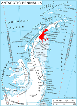
Delusion Point
Delusion Point er eit nes heilt aust på ein rygg som dannar sørveggen av Cranebreen, på austkysten av Graham Land. Neset vart fotografert frå lufta av sir Hubert Wilkins på ein flytur den 20. desember 1928, og vart namngjeve av Falkland Islands Dependencies Survey, som kartla det i 1947.[1]
| Delusion Point | |||
| nes | |||
| Land | |||
|---|---|---|---|
| Stad | Graham Land | ||
| - koordinatar | 65°23′S 62°0′W / 65.383°S 62.000°W | ||
| Administrert under | Antarktistraktaten | ||
 Delusion Point 65°23′00″S 62°00′00″W / 65.3833°S 62°W | |||
Kjelder
endre- Denne artikkelen bygger på «Delusion Point» frå Wikipedia på engelsk, den 16. desember 2012.
- Wikipedia på engelsk oppgav desse kjeldene:
- ↑ «Delusion Point». Geographic Names Information System. United States Geological Survey, United States Department of the Interior. Henta 18. oktober 2012.
Denne artikkelen inneheld stoff som er offentleg eige frå United States Geological Survey-artikkelen «Delusion Point» (innhald frå Geographic Names Information System).

