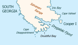
Drygalskifjorden
Drygalskifjorden er ein fjord 1,5 km brei og som trengjer nordvestover 13 km like nord for Nattriss Head langs søraustkysten av Sør-Georgia. Ho vart kartlagd av Den andre tyske antarktisekspedisjonen, 1911–12, under Wilhelm Filchner, og kalla opp etter professor Erich von Drygalski, leiaren for Den første tyske antarktisekspedisjonen, 1901–03.[1]
| Drygalskifjorden | |||
| bukt | |||
Drygalskifjorden (innløpet til Larsen Harbour)
| |||
| Land | |||
|---|---|---|---|
| Stad | Sør-Georgia | ||
| - koordinatar | 54°49′S 36°0′W / 54.817°S 36.000°W | ||
| Lengd | 13 km | ||
 Drygalskifjorden 54°49′00″S 36°00′00″W / 54.8167°S 36°W | |||
| Wikimedia Commons: Drygalski Fjord, South Georgia | |||
I følgje L. Harrison Matthews kan Drygalskifjorden ha vore staden der Anthony de la Roché var to veker under opphaldet sitt på øya i april 1675.[2]
Kjelder
endre- ↑ «Drygalskifjorden». Geographic Names Information System. United States Geological Survey, United States Department of the Interior. Henta 16. oktober 2012.
- ↑ Matthews, L.H. (1931). Sør-Georgia: The British Empire's Sub-Antarktis Outpost. Bristol: John Wright; and London: Simpkin Marshall.
Denne artikkelen inneheld stoff som er offentleg eige frå United States Geological Survey-artikkelen «Drygalskifjorden» (innhald frå Geographic Names Information System).


