Fil:Botley Hill trig point - geograph.org.uk - 788400.jpg
Storleik på førehandsvising: 411 × 599 pikslar. Andre oppløysingar: 164 × 240 pikslar | 439 × 640 pikslar.
Opphavleg fil (439 × 640 pikslar, filstorleik: 80 KB, MIME-type: image/jpeg)
Følgjande er henta frå filomtalen åt denne fila på Wikimedia Commons:
Skildring
| Skildring |
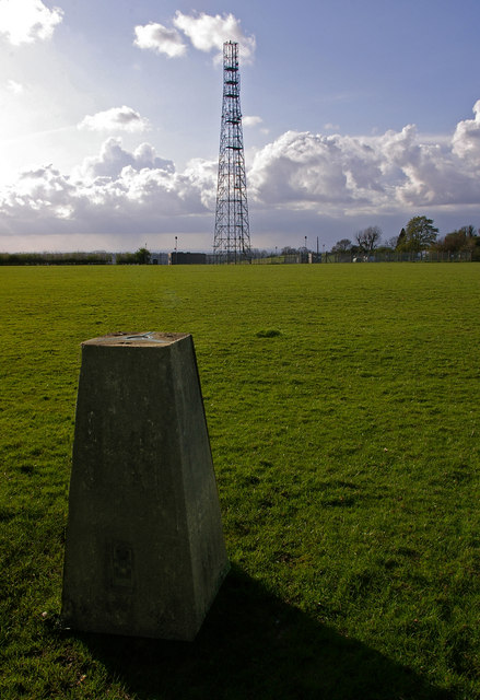
English: Botley Hill trig point. The highest trig point on the North Downs (benchmark at 266.88m), and until recently most references claimed that this also marked the highest point of the whole of the North Downs. However, in practice, this is not the case. Firstly the land seems to rise slightly to the east, and there is another area slightly to the west which also lies above the 265m contour, with the same 267m spot height (although older maps give the latter point a slightly lower height than the trig point when measured in feet). But more significantly, old 1 inch maps show a spot height of 882 feet next to the water tower in the next square over (see 788446), compared with only 877 feet at the trig point, implying that the true summit point of the North Downs could well be there.
This has since been confirmed by surveys. Unfortunately, views to the south at this point are blocked by the woodland of Titsey Plantation, and the nature of the plateau means that the expected view north over London is not available. Behind is one of a number of masts near Botley Hill, this one beside Botley Hill Farm. |
| Dato | |
| Kjelde | From geograph.org.uk |
| Opphavsperson | Ian Capper |
| Namngjeving (påkravd av lisensen) | Ian Capper / Botley Hill trig point / |
| Kameraposisjon | | Dette og andre bilete på denne posisjonen i: OpenStreetMap |
|---|
_heading:315.00&language=nn)
| Objektposisjon | | Dette og andre bilete på denne posisjonen i: OpenStreetMap |
|---|
_heading:315.00&language=nn)
Lisensiering:

|
This image was taken from the Geograph project collection. See this photograph's page on the Geograph website for the photographer's contact details. The copyright on this image is owned by Ian Capper and is licensed for reuse under the Creative Commons Attribution-ShareAlike 2.0 license.
|
Denne filen er lisensiert under lisensen Creative Commons Navngivelse-DelPåSammeVilkår 2.0 Generisk
Namngjeving: Ian Capper
- Du står fritt til å:
- til å dela – til å kopiera, distibuera og overføra arbeidet
- til å blanda – til å endra verket
- På desse vilkåra:
- namngjeving – Du lyt godskriva verket på den måten som opphavpersonen eller lisensgjevaren har oppgjeve (men ikkje på ein slik måte at det kan verka som om dei går god for deg eller måten du nyttar verket på).
- del på same vilkåra – Om du remiksar, omarbeider, eller på annan måte byggjer på dette verket, kan du berre distribuera resultatet under den same eller ein samsvarande lisens som denne.
Filhistorikk
Klikk på dato/klokkeslett for å sjå fila slik ho var på det tidspunktet.
| Dato/klokkeslett | Miniatyrbilete | Oppløysing | Brukar | Kommentar | |
|---|---|---|---|---|---|
| gjeldande | 20. februar 2011 kl. 02:47 | | 439 × 640 (80 KB) | GeographBot | == {{int:filedesc}} == {{Information |description={{en|1=Botley Hill trig point The highest trig point on the North Downs (benchmark at 266.88m), and until recently most references claimed that this also marked the highest point of the whole of the North |
Filbruk
Den følgjande sida bruker denne fila:
Global filbruk
Desse andre wikiane nyttar fila:
- Bruk på en.wikipedia.org
- Bruk på www.wikidata.org