Fil:British Columbia-map.png
Høgare oppløysing er ikkje tilgjengeleg.
British_Columbia-map.png (280 × 230 pikslar, filstorleik: 14 KB, MIME-type: image/png)
Følgjande er henta frå filomtalen åt denne fila på Wikimedia Commons:

|
Ein vektorversjon av dette biletet (SVG) er tilgjengeleg.
Han bør verta nytta i staden for dette rasterbiletet der han er betre. File:British Columbia-map.png → File:British Columbia, Canada.svg
For meir informasjon om vektorgrafikk, les om overgangen til SVG på commons. Det finst òg informasjon om støtta MediaWiki har for SVG-bilete. |
 |
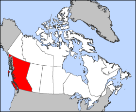
Map of British Columbia
Projection: Lambert azimuthal equal-area
Geospatial data from: The Atlas of Canada, The National Atlas of the United States archive copy at the Wayback Machine and U.S. Geological Survey
Cartographer: John Fowler
| Eg, opphavsrettshaldaren til dette verket, frigjev dette verket til ålmenta. Dette gjeld over heile verda. I somme landa er dette kan henda ikkje rettsleg mogeleg. I det fall: Eg gjev kven som helst rettane til å nytta dette verket for kva som helst føremål og utan vilkår, minder vilkår er kravde etter lova. |
Filhistorikk
Klikk på dato/klokkeslett for å sjå fila slik ho var på det tidspunktet.
| Dato/klokkeslett | Miniatyrbilete | Oppløysing | Brukar | Kommentar | |
|---|---|---|---|---|---|
| gjeldande | 24. mars 2005 kl. 14:12 | | 280 × 230 (14 KB) | Voyager | Map of British Columbia Projection: Lambert azimuthal equal-area Geospatial data from: [http://atlas.gc.ca/ The Atlas of Canada], [http://www.nationalatlas.gov/ The National Atlas of the United States] and [http://www.usgs.gov U.S. Geological Survey] C |
Filbruk
Det finst ikkje noka side som bruker denne fila.
Global filbruk
Desse andre wikiane nyttar fila:
- Bruk på fr.wikipedia.org
- Bruk på he.wikivoyage.org