Fil:Konstanz - 27-48.jpg

Opphavleg fil (3 388 × 4 995 pikslar, filstorleik: 3,47 MB, MIME-type: image/jpeg)
Følgjande er henta frå filomtalen åt denne fila på Wikimedia Commons:
|
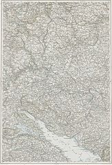
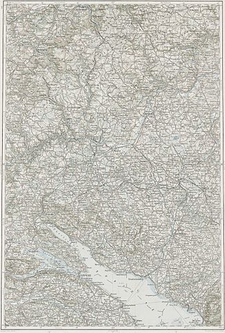
Deutsch: Blatt 27-48 der Generalkarte von Mitteleuropa 1:200.000 der Franzisco-Josephinischen Landesaufnahme, Österreich-Ungarn, ab 1887. Die Blattmitte liegt bei 48° n.Br. und 27° ö.L. (östlich von Ferro, nicht Greenwich!). English: Sheet 27-48 of the General Map of Central Europe, scale 1:200,000, edited 1887 ff. See 3rd Military Mapping Survey of Austria-Hungary for details. The center of the sheet is 48° North, 27° East (east of Ferro, not Greenwich!).
← Nachbarblätter. Klicken Sie auf eine Miniatur, um zu diesem Blatt zu gelangen.
← Neighbouring sheets. Click thumbnail to navigate |


.jpg)
Skildring
| Skildring | 3rd Military Mapping Survey of Austria-Hungary - Konstanz |
| Dato | |
| Kjelde | http://lazarus.elte.hu/hun/moterkep.htm - László ZENTAI |
| Opphavsperson | Military mapping authority of Austria-Hungary |
Lisensiering:
|
Dette verket er falt i det fri i Noreg, og dei landa som har opphavsrettsleg vernetid på 70 år etter opphavsmannen sin død, eller kortare.
| |
| Denne fila er fastsett å vera fri for kjende avgrensingar under opphavsrettlovgjeving, medrekna alle relaterte og nærliggjande rettar. | |
Filhistorikk
Klikk på dato/klokkeslett for å sjå fila slik ho var på det tidspunktet.
| Dato/klokkeslett | Miniatyrbilete | Oppløysing | Brukar | Kommentar | |
|---|---|---|---|---|---|
| gjeldande | 10. mars 2007 kl. 09:15 | | 3 388 × 4 995 (3,47 MB) | Szilas | == Összefoglaló == 3rd Military Mapping Survey of Austria-Hungary - Konstanz Category:Old maps of Austria-Hungary == Licensing == {{PD-old}} |
Filbruk
Det finst ikkje noka side som bruker denne fila.
Global filbruk
Desse andre wikiane nyttar fila:
- Bruk på hu.wikibooks.org