Fil:Thuja occidentalis range map.png
Storleik på førehandsvising: 589 × 599 pikslar. Andre oppløysingar: 236 × 240 pikslar | 472 × 480 pikslar | 755 × 768 pikslar | 1 007 × 1 024 pikslar | 1 644 × 1 672 pikslar.
Opphavleg fil (1 644 × 1 672 pikslar, filstorleik: 381 KB, MIME-type: image/png)
Følgjande er henta frå filomtalen åt denne fila på Wikimedia Commons:
Skildring
| Skildring |
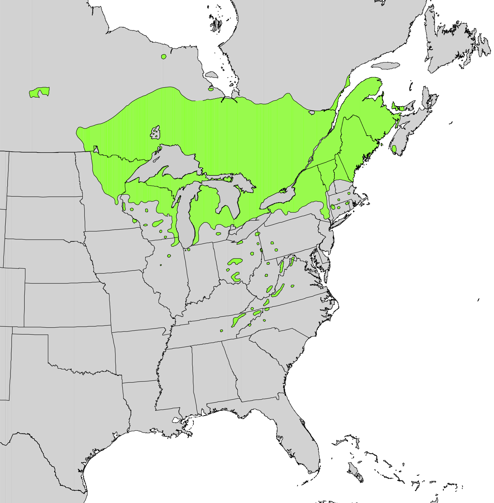
English: Range map of Thuja occidentalis |
|||
| Dato | ||||
| Kjelde | Digital representation of "Atlas of United States Trees" by Elbert L. Little, Jr. [1] | |||
| Opphavsperson | U.S. Geological Survey | |||
| Løyve (Gjenbruk av denne fila) |
|
Lisensiering:
This work is in the public domain in the United States because it is a work prepared by an officer or employee of the United States Government as part of that person’s official duties under the terms of Title 17, Chapter 1, Section 105 of the US Code.
Note: This only applies to original works of the Federal Government and not to the work of any individual U.S. state, territory, commonwealth, county, municipality, or any other subdivision. This template also does not apply to postage stamp designs published by the United States Postal Service since 1978. (See § 313.6(C)(1) of Compendium of U.S. Copyright Office Practices). It also does not apply to certain US coins; see The US Mint Terms of Use.
|
 | |
| Denne fila er fastsett å vera fri for kjende avgrensingar under opphavsrettlovgjeving, medrekna alle relaterte og nærliggjande rettar. | ||
Filhistorikk
Klikk på dato/klokkeslett for å sjå fila slik ho var på det tidspunktet.
| Dato/klokkeslett | Miniatyrbilete | Oppløysing | Brukar | Kommentar | |
|---|---|---|---|---|---|
| gjeldande | 11. oktober 2012 kl. 23:21 | | 1 644 × 1 672 (381 KB) | Pinethicket | {{Information |Description ={{en|1=Range map of ''Thuja occidentalis'' }} |Source =Digital representation of "Atlas of United States Trees" by Elbert L. Little, Jr. [http://esp.cr.usgs.gov/data/atlas/little/] |Author =U.S. Geological... |
Filbruk
Den følgjande sida bruker denne fila:
Global filbruk
Desse andre wikiane nyttar fila:
- Bruk på ar.wikipedia.org
- Bruk på arz.wikipedia.org
- Bruk på ast.wikipedia.org
- Bruk på bg.wikipedia.org
- Bruk på ca.wikipedia.org
- Bruk på ceb.wikipedia.org
- Bruk på cs.wikipedia.org
- Bruk på el.wikipedia.org
- Bruk på en.wikipedia.org
- Bruk på eu.wikipedia.org
- Bruk på fa.wikipedia.org
- Bruk på fr.wikipedia.org
- Bruk på he.wikipedia.org
- Bruk på hr.wikipedia.org
- Bruk på hy.wikipedia.org
- Bruk på is.wikipedia.org
- Bruk på ja.wikipedia.org
- Bruk på mk.wikipedia.org
- Bruk på nl.wikipedia.org
- Bruk på no.wikipedia.org
- Bruk på pl.wikipedia.org
- Bruk på pt.wikipedia.org
- Bruk på ro.wikipedia.org
- Bruk på sk.wikipedia.org
- Bruk på sl.wikipedia.org
- Bruk på sv.wikipedia.org
- Bruk på tr.wikipedia.org
- Bruk på uk.wikipedia.org
- Bruk på www.wikidata.org
- Bruk på zh.wikipedia.org