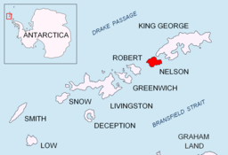
Duthoit Point
Duthoit Point er eit nes på austenden av Nelson Island i Sør-Shetlandsøyane. Neset finst på kart attende til 1822. Det vart kartlagd på ny av Discovery Investigations, 1934–35, og kalla opp etter Arthur Duthoit, ein teiknar i Hydrographic Office i Admiralitetet på den tida.[1]
| Duthoit Point | |||
| nes | |||
| Land | |||
|---|---|---|---|
| Stad | Sør-Shetlandsøyane | ||
| - koordinatar | 62°19′S 58°50′W / 62.317°S 58.833°W | ||
| Administrert under | Antarktistraktaten | ||
 Duthoit Point 62°19′00″S 58°50′00″W / 62.3167°S 58.8333°W | |||
Kjelder
endre- ↑ «Duthoit Point». Geographic Names Information System. United States Geological Survey, United States Department of the Interior. Henta 17. oktober 2012.
Denne artikkelen inneheld stoff som er offentleg eige frå United States Geological Survey-artikkelen «Duthoit Point» (innhald frå Geographic Names Information System).

