Fil:Victoria Docks 1872.jpg

Storleik på førehandsvising: 800 × 450 pikslar. Andre oppløysingar: 320 × 180 pikslar | 640 × 360 pikslar | 1 176 × 662 pikslar.
Opphavleg fil (1 176 × 662 pikslar, filstorleik: 316 KB, MIME-type: image/jpeg)
Følgjande er henta frå filomtalen åt denne fila på Wikimedia Commons:
Skildring
| Beskrivelse |
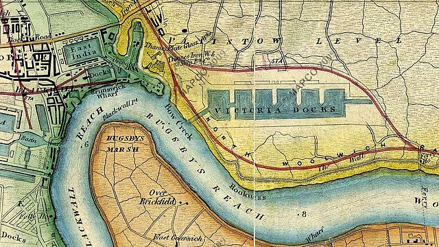
English: Map c.1872 showing Victoria Docks (now Royal Victoria Dock), Blackwall, the area that is now Canning Town and parts of the Greenwich Peninsula, London, UK. Also shows location of Thames Ironworks & Shipbuilding Company. |
|||||||||
| Dato | ca. 1872 | |||||||||
| Kjelde |
Wyld's New Topographical Map Of The Country In The Vicinity Of London c 1872.
|
|||||||||
| Skapar |
Wyld's New Topographical Map Of The Country In The Vicinity Of London c 1872. |
|||||||||
| Geotemporale data | ||||||||||
| Avgrensningsboks |
|
|||||||||
| Georeferering | ||||||||||
Lisensiering:
This media file is in the public domain in the United States. This applies to U.S. works where the copyright has expired, often because its first publication occurred prior to January 1, 1929, and if not then due to lack of notice or renewal. See this page for further explanation.
|
 | |
 |
This image might not be in the public domain outside of the United States; this especially applies in the countries and areas that do not apply the rule of the shorter term for US works, such as Canada, Mainland China (not Hong Kong or Macao), Germany, Mexico, and Switzerland. The creator and year of publication are essential information and must be provided. See Wikipedia:Public domain and Wikipedia:Copyrights for more details.
|
Opphavleg opplastingslogg
The original description page was here. All following user names refer to en.wikipedia.
- 2010-06-26 18:51 SasiSasi 1176×662× (323144 bytes) {{Information |Description = Mapc.1872 showing Victoria Docks (now Royal Victoria Docks), the area that is now Canning Town and parts of the Greenwich Peninsula, London, UK |Source = http://archivemaps.com/mapco/wyld1872/wyld23.htm and http:/
Filhistorikk
Klikk på dato/klokkeslett for å sjå fila slik ho var på det tidspunktet.
| Dato/klokkeslett | Miniatyrbilete | Oppløysing | Brukar | Kommentar | |
|---|---|---|---|---|---|
| gjeldande | 17. mai 2011 kl. 12:56 | | 1 176 × 662 (316 KB) | File Upload Bot (Magnus Manske) | {{BotMoveToCommons|en.wikipedia|year={{subst:CURRENTYEAR}}|month={{subst:CURRENTMONTHNAME}}|day={{subst:CURRENTDAY}}}} {{Information |Description={{en|Mapc.1872 showing Victoria Docks (now Royal Victoria Docks), the area that is now Canning Town and part |
Filbruk
Den følgjande sida bruker denne fila:
Global filbruk
Desse andre wikiane nyttar fila:
- Bruk på arz.wikipedia.org
- Bruk på de.wikipedia.org
- Bruk på en.wikipedia.org
- Bruk på et.wikipedia.org
- Bruk på fi.wikipedia.org
- Bruk på fr.wikipedia.org
- Bruk på it.wikipedia.org
- Bruk på nl.wikipedia.org