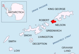
Harmony Cove
Harmony Cove er ei vik mellom Harmony Point og The Toe på vestsida av Nelson Island i Sør-Shetlandsøyane i Antarktis. Ho vart namngjeven av amerikanske selfangarar kring 1820 etter selskuta «Harmony», under kaptein Thomas Ray, ein av fleire amerikanske selfangarar som hadde base i Harmony Cove i sesongen 1820–21.[1][2]
| Harmony Cove | |||
| vik | |||
| Land | |||
|---|---|---|---|
| Koordinatar | 62°19′S 59°12′W / 62.317°S 59.200°W | ||
| Administrert under | Antarktistraktaten | ||
 Harmony Cove 62°19′00″S 59°12′00″W / 62.3167°S 59.2°W | |||
Kjelder
endre- ↑ «Harmony Cove». Geographic Names Information System. United States Geological Survey, United States Department of the Interior. Henta 20. november 2012.
- ↑ Alberts, Fred G., red. (June, 1995). Geographic Names av Antarktis (PDF) (second utg.). USA Board on Geographic Names. s. 313. Henta 14. oktober 2012.
Denne artikkelen inneheld stoff som er offentleg eige frå United States Geological Survey-artikkelen «Harmony Cove» (innhald frå Geographic Names Information System).

