Pourquoi Pas Island
(Omdirigert frå Porquoi Pas Island)
Pourquoi Pas Island er ei fjellendt øy som ligg mellom Bigourdan Fjord og Bourgeois Fjord utanfor vestkysten av Graham Land. Ho vart oppdaga av Den franske antarktisekspedisjonen under Charcot, 1908-10. Øya vart kartlagd meir nøyaktig av British Graham Land Expedition (BGLE) under Rymill, 1934–37, som namngav ho etter ekspedisjonsskipet til Charcot, «Pourquoi-Pas?».
| Pourquoi Pas Island | |||
| øy | |||
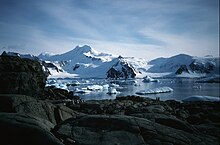
Pourquoi Pas Island sett frå Horseshoe Island
| |||
| Land | |||
|---|---|---|---|
| Stad | Antarktis | ||
| - koordinatar | 67°41′S 67°28′W / 67.683°S 67.467°W | ||
| Lengd | 27 km | ||
| Areal | 405 km² | ||
| Folketal | 0 | ||
| Administrert under | Antarktistraktaten | ||
 Pourquoi Pas Island 67°41′00″S 67°28′00″W / 67.683333333333°S 67.466666666667°W | |||
| Wikimedia Commons: Pourquoi Pas Island | |||
Sjå òg
endreKjelder
endreDenne artikkelen inneheld stoff som er offentleg eige frå United States Geological Survey-artikkelen «Pourquoi Pas Island» (innhald frå Geographic Names Information System).
