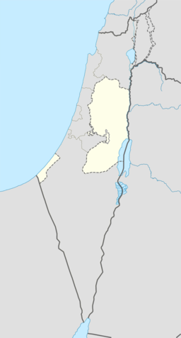
Aboud
Aboud eller 'Abud (arabisk عابود, `Ābūd) er ein palestinsk landsby i Ramallah og al-Bireh guvernement, sentralt på Vestbreidda, Dei palestinske territoria, kring 22 kilometer nordvest for Ramallah og 30 kilometer nord for Jerusalem. Andre byar i nærleiken er al-Lubban i nordaust og Bani Zeid i nordvest. Folkesetnaden i Aboud er hovudsakleg kristne. I følgje Palestinsk statistisk sentralbyrå hadde landsbyen eit folketal på kring 2 084 innbyggjarar i 2007.[2] Nær landsbyen ligg mange naturlege kjelder som er kjelda til Yarkonelva.
| Aboud | |||
| عابود, 'Aboud, Abboud | |||
| kommune | |||
Aboud, sett frå sør
| |||
| Namneopphav: Abud, førenamn, frå «å tilbe»[1] | |||
| Land | |||
|---|---|---|---|
| Guvernement | Ramallah og al-Bireh guvernement | ||
| Koordinatar | 32°00′54.06″N 35°04′05.28″E / 32.0150167°N 35.0681333°E | ||
| Areal | 15,0 km² | ||
| Folketal | 2 084 (2006) | ||
| Folketettleik | 139 / km² | ||
| Borgarmeister | Elias Azar | ||
 Aboud 32°00′54″N 35°04′05″E / 32.015016666667°N 35.068133333333°E | |||
| Wikimedia Commons: Aboud | |||
Historie
endreHer finst spor etter romarar, bysantinarar, krossfararar, ajjubidane, mamelukkane og osmanarane.[3] I krossfarartida vart han kalla Casale Santa Maria.[3] I 1225 skreiv Yaqut al-Hamawi om Aboud at han var ein «liten by i Filastin-provinsen, nær Jerusalem. Namnet er hebraisk, og har vorte arabifisert.»[4] Den arabiske historikaren al-Maqrizi nemnte staden på 1300-talet.[3]
Osmansk tid
endreHan var oppført i osmanske skattelister som ein del av Ramla nahiya i Gaza sanjak.
I 1596 hadde han eit folketal på 19 kristne hushaldningar og 16 muslimske hushaldningar, og betalte skatt for kveite, bygg, og andre varer.[5] Han vart seinare ein del av provinsen Bani Zeid.[3]
I 1870 vitja den franske oppdagaren Victor Guérin Aboud og estimerte at han hadde kring 800 innbyggjarar, halvparten «skismatiske gerkarar» og halvparten muslimar.[6]
I 1882 skildra Palestine Exploration Fund i «Survey of Western Palestine» landsbyen som «ein stor og blømande kristen landsby, i stein, og nesten alle husa er merka med ein raudfarga kross», med eit folketal på 400 ortodokse kristne og 100 muslimar.[7]
Det britiske mandatet
endreI folketeljinga i 1922 hadde Aboud eit folketal på 754, 402 kristne og 352 muslim.[8] I folketeljinga i 1931 hadde folketalet auka til 910, 470 kristne og 440 muslimar, i 215 hus.[9]
I 1945 var folketalet 1 080, alle arabarar, medan det samla landarealet var 15 007 mål, i følgje ei offisiell landmåling.[10] Av dette var 4 843 for plantasjar og irrigert land, 1 905 for korn,[11] medan 55 mål var klassifisert som utbygde område.[12]
Kjelder
endre- Denne artikkelen bygger på «Aboud» frå Wikipedia på engelsk, den 22. september 2015.
- Wikipedia på engelsk oppgav desse kjeldene:
- Barron, J. B., red. (1923). Palestine: Report and General Abstracts of the Census of 1922. Government of Palestine.
- Clermont-Ganneau, Charles Simon (1898). Recueil d'archéologie orientale (på fransk) 2. Paris. (p. 166 ff )
- Conder, Claude Reignier; Kitchener, H. H. (1882). The Survey of Western Palestine: Memoirs of the Topography, Orography, Hydrography, and Archeology 2. London: Committee of the Palestine Exploration Fund. (s. 302-03, 305, 347)
- Dauphin, Claudine (1998). La Palestine byzantine, Peuplement et Populations. BAR International Series 726 (på fransk). III : Catalogue. Oxford: Archeopress.
- Ellenblum, Ronnie (2003). Frankish Rural Settlement in the Latin kingdom of Jerusalem. Cambridge University Press. ISBN 0521521874. (p. 128 -134 )
- Guérin, Victor (1875). Description Géographique Historique et Archéologique de la Palestine (på fransk). 2: Samarie, pt. 2. Paris: L'Imprimerie Nationale.
- Hadawi, Sami (1970). Village Statistics of 1945: A Classification of Land and Area ownership in Palestine. Palestinsk frigjeringsorganisasjon forskingssentral.
- Hütteroth, Wolf-Dieter; Abdulfattah, Kamal (1977). Historical Geography of Palestine, Transjordan and South Syria in the Late 16th Century. Erlanger Geographische Arbeiten, Sonderband 5. Erlangen, Tyskland: Vorstand der Fränkischen Geographischen Gesellschaft. ISBN 3-920405-41-2.
- le Strange, Guy (1890). «Palestine Under the Moslems: A Description of Syria and the Holy Land from A.D. 650 to 1500». Committee of the Palestine Exploration Fund., London,
- Mills, E., red. (1932). Census of Palestine 1931. Population of Villages, Towns and Administrative Areas (PDF). Jerusalem: Government of Palestine.
- Palmer, E. H. (1881). The Survey of Western Palestine: Arabic and English Name Lists Collected During the Survey by Lieutenants Conder og Kitchener, R. E. Transliterated and Explained by E.H. Palmer. Committee of the Palestine Exploration Fund.
- Pringle, Denys (1993). The Churches of the Crusader Kingdom of Jerusalem: A-K (excluding Akko and Jerusalem) 1. Cambridge University Press. (s. 17 - 23 )
- Röhricht, Reinhold (1893). (RRH) Regesta regni Hierosolymitani (MXCVII-MCCXCI) (på latin). Berlin: Libraria Academica Wageriana. (RRH, s. 113, No. 433), (RRH, s. 137-138, No. 518), (RRH, s. 145, No. 547), ( RRH, s. 258-260, No. 983)
- Röhricht, Reinhold (1904). (RRH Ad) Regesta regni Hierosolymitani Additamentum (på latin). Berlin: Libraria Academica Wageriana. (RRH Ad, s. 28, No. 458a)
- ↑ Palmer, 1881, s. 221
- ↑ 2007 PCBS Census. Palestinsk statistisk sentralbyrå. s.112.
- ↑ 3,0 3,1 3,2 3,3 H. Taha (1997). «A salvage excavation at the 'Abudiyah Church in Abud – Samaria» (PDF). Liber Annuus 47: 359–374 and plates 17–20.
- ↑ Yaqut al-Hamawi sitert i le Strange, 1890, s. 382.
- ↑ Hütteroth and Abdulfattah, 1977, s. 156
- ↑ Guérin, 1875, s. 87 - 90
- ↑ Conder og Kitchener, 1882, SWP II, s. 289
- ↑ Barron, 1923, Table VII, Ramallah underdistrikt, s. 16
- ↑ Mills, 1932, s. 47
- ↑ Government of Palestine, Department of Statistics. Village Statistics, April, 1945. Sitert i S. Hadawi, Village Statistics, 1945. PLO Research Sentral, 1970, s. 64
- ↑ Government of Palestine, Department of Statistics. Village Statistics, April, 1945. Sitert i S. Hadawi, Village Statistics, 1945. PLO Research Sentral, 1970, s. 111
- ↑ Government of Palestine, Department of Statistics. Village Statistics, April, 1945. Sitert i S. Hadawi, Village Statistics, 1945. PLO Research Sentral, 1970, s. 161


